Without water there is no life. If it does not flow out of the tap from the municipal dam or high mounted tank we have to catch the rain or pull it out of the nearby stream. In arid areas that nearby stream may be many meters underground. Water from these aquifers takes years to filter down the subterranean system. Once it is pumped onto the surface and used for irrigation or domestic consumption most of it finds its way into the sea[1]
Underground water is replaced by seepage from mountainous snow and ice melt and rain. Ancient civilizations engineered sophisticated collection systems for catching and holding rainwater in arid zones. The Nabataeans controlled the water supply by use of dams, cisterns and carved channels in the rock faces surrounding the city of Petra. Although it did experience flash flooding which the Siq (shaft naturally funneled into the Wadi Musa[2]
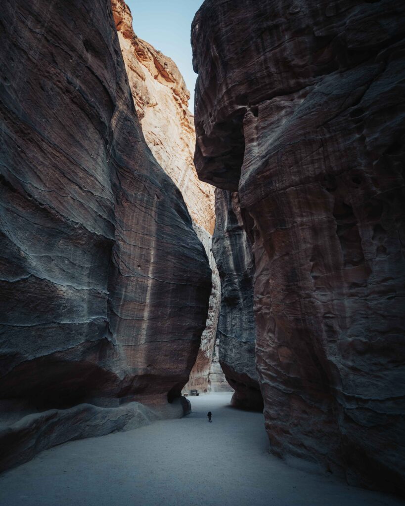
Apparently an earthquake in 363 AD destroyed much of the infrastructure and the city and its trade declined.
The driest regions of Earth give clues to water capture and retention. The infamous Atacama Desert of Chile has extremely low humidity. There rocks support endolithic microbes on their surface which are the source of water. David Kisailus from the University of California, Irvine, located bacteria on gypsum in the Atacama. The rock predominately hydrated calcium sulfate was etched by the cyanobacteria and dehydrated it to anhydrate. Spectroscopy revealed that the bacteria secreted an acidic extracellular deposit that may have altered the chemistry to release the water from the rock.[3]
Another approach observed in the high sand dunes of the Atacama is the water catching technique of the people of Falda Verde. Mostly the only moisture to fall on the western slopes of the Andes bordering the Atacama arrives as mist from warm ocean air condensing in the cool high altitude. Nets are erected to catch the water droplets which are channeled into tanks. Across the Atlantic the highly specialized beetle Stenocara gracilipes or Namib Desert beetle survives by collecting water particles on its lumpy textured back. To drink it faces up wind raising its body angle to 450, water gathers on its hard outer wings with Hydrophilc lumps.
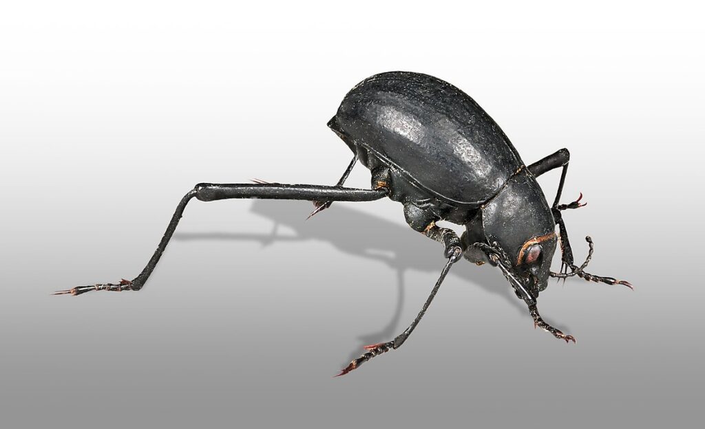
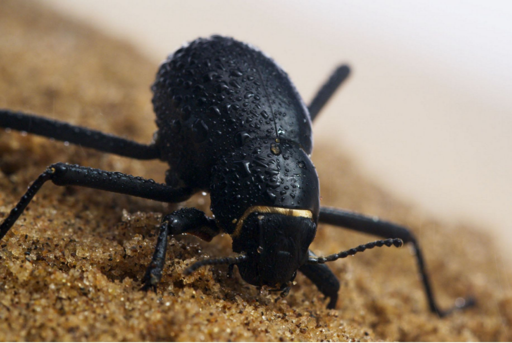
When enough water combines into droplets big enough to overcoming the electrostatic attraction of the lumps and the 30 km/h sea breeze, the drop rolls down the waxy hydrophobic channels into the beetles’ mouth parts. Their performance is that efficient they can collect water from dew settling.[4] Some of the tenebrionidae have hairs around their necks to transfer the droplets around to their mouths.
Man controls the majority of Surface Freshwater
Most of the world’s fresh water is found in icecaps and glaciers, 30 percent is in artisian basins. Reservoirs and constructed dams account for only 0.38 percent of water storage on the Earth’s surface, but they manage 57 percent of the change of all fresh surface water availability. [5] Fresh water is threatened by over development of impermeable surfaces like concrete, bitumen, and buildings that increase run-off into storm water drainage. The Earth does not have the opportunity to soak it up in plants, soils, or seep into aquifers. The vast majority of Earth’s fresh water is unavailable to its living species.[6]
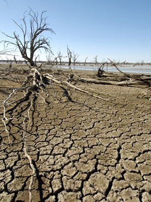
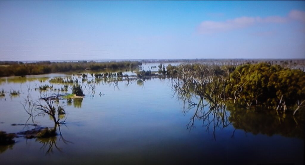
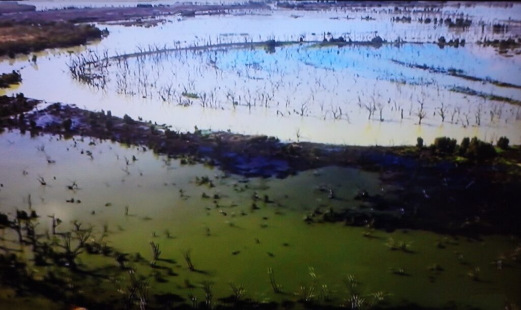
The scale of human intervention has dramatic effects on water shortage in natural ecosystems. Till recently the Menindee lake system had no water flow in it for five years.[7]
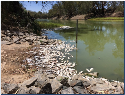
“Of all the volume changes in freshwater bodies around the planet – all the floods, droughts and snowmelt that push lake levels up and down – humans have commandeered almost 60 percent of that variability,” Laurence Smith environmental scientist from Brown University.[8]
The Human interference with the world’s water cycle is on a par with the impact on our atmosphere and land habitat. As the world warms the water in lakes, rivers, streams and our dams will evaporate to a greater extent. The water vapor once airborne can move usually to a cooler air source to condense as snow or rain. Some will fall on mountains and return to water courses to be returned to the water cycle but the moisture that falls into the saline oceans is no longer of use to most of us.
Almost all of the longest rivers have water controlling barriers; only 21 have a clear passage to a sea. Animals depend on fresh water habitat like; crayfish, mussels and fresh water spawning fish are disappearing at a faster rate than marine species and even faster than rainforest species. Over one billion of the human species want for clean drinking water and more than twice that many people rely on unsanitary waste disposal[9].
Repercussions for rivers
River flow from and through watersheds (catchment landscapes) picking up sediment, nutrients and pollution, carrying then depositing them down stream. Chemicals like nitrogen, phosphorous and potassium common in fertilizers, road sediment and household drainage accumulates at the low areas. These additions will influence the natural balance of plants and animals.
Dams interrupt free flow into standing pools, likely straightening and deepening a river bed. The impact can reduce water quality, block fish migration, and inhibit reproduction of freshwater species.
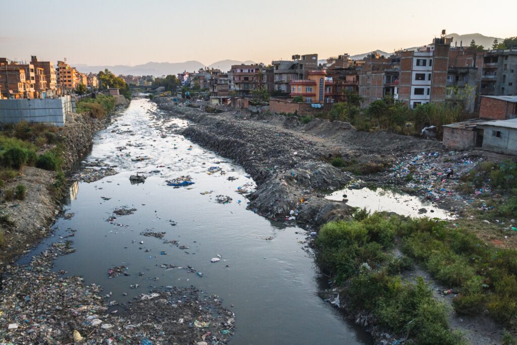
Chemicals from agriculture, industrial sites, sewerage and urban run-off can pollute water courses. Detection can be subtle only apparent after years of toxic accumulation resulting in disease and deformities in amphibians, and cancer in people. The rivers of the Colorado, the Murray have numerous instances of water shortage disasters. After 15 years of diminishing snow falls on the Rockies Lake Powell serving 40 million people has been draught stricken since 2012. Interstate authorities argue over water distribution from the Tennessee River and the Chattahoochee and the Flint and the Apalachicola Rivers.[10],[11]
Pumping water out of underground aquifers, rivers and creeks, and wetlands for irrigation, urban consumption or industrial purposes can decimate water sources. Wildlife is can be wiped out and human communities reduced to arid or salt clogged conditions. With the increase of climate affecting chemicals in the atmosphere rainfall is less predictable. And extreme weather events are most likely to occur; flooding will be more hazardous, and dry spells longer and more intense. Humans have choices and alternatives, wild animals depend on freshwater in their habitat.
Responsibility
Where does the responsibility for your freshwater lie?
The individual user could check the source, the supply infrastructure and individual receptacles are free of introduced or in-built contamination. The Romans never identified lead water pipes as a hazard.
The water supply company (or authority), the local municipal council, state governments are usually considered responsible. Some councils simply gave up and supply commercially package drinking water after ‘fracking’ practices were used to separate natural gas from the ground structure.
Freshwater – Biodiversity
Eco-systems in freshwater host populations for 12 percent of animal species and 40 percent of fish. These habitats have a large array of fish, amphibians, mollusks, crustaceans and insects which provides sustenance for large flocks of endemic and migratory birds. Plants are an essential contributors to the freshwater eco-systems giving food and shelter for animals.
However because they are vulnerable to run-off pollutants and drainage, they exhibit up to 15 times greater extinction rates than in marine habitats.[12]
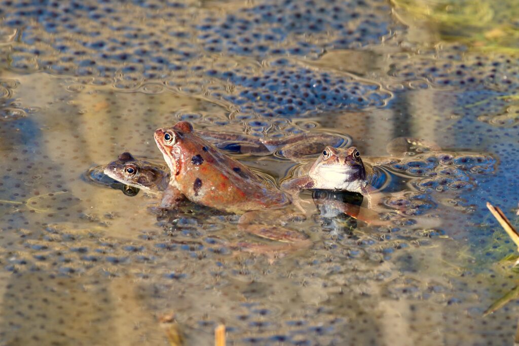
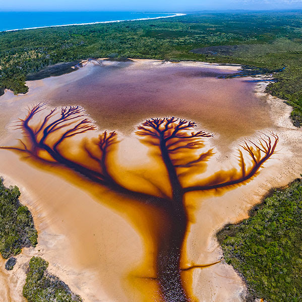
The diversity of freshwater habitats is affect by the local topography. Rainfall at a river’s headwaters [source] flows downhill through the area where all water from tributary streams drain into the same river system known as its water shed. This moving water flows through varying geography. The less steep the slope in the land the longer the water will seep into it. The slower moving water courses see a variety of wetlands; marshes, sloughs, soaks and bogs, or seasonal pools known as vernal pools.
Where no outlet is found water accumulates as a pond or lake. Some water will infiltrate the ground and contribute to the subterranean water system.
Ice and snow can contain water for centuries before melting to release water at high altitudes to add another diversity to water cycles.
Freshwater Habitats
RIVERS
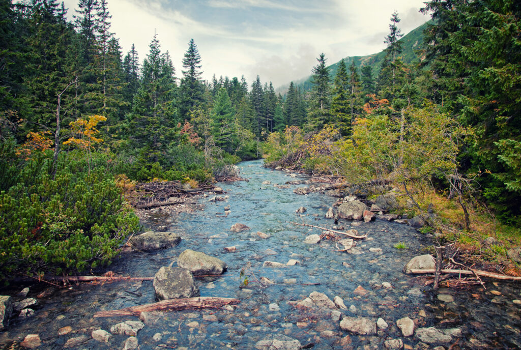
The steepness of the gradient, preferred by hydro engineers, controls the composition of the water course. At speed water forces all but large rocks to roll and move down stream. The size of particles like pebbles grit and silt settle into the river bed as the water slows.
Locations below cascades have excellent aeration and waste is moved on. Such a site suits salmon egg lodging between pebbles. Shallow pools with slow currents suit small fish, crustaceans, amphibians and mollusks. Consequently wetlands attract birds and small mammals. Riparian vegetation affects microhabitats providing shade and cooling and protection within the root structures. Plants attract insects which encourages microorganisms in the decaying leaf litter. Each stream has dissolved minerals eroded from the geology it flowed through which influences the types of wildlife it supports.
PONDS and LAKES
Often thought of as closed systems like a pool with little outflow. Where a water outflow does not exist, fish, mollusks, crustaceans and all but large amphibians stay in them. When there is little flushing action toxins are accumulate, as can invasive species of plants or animals which frequently out compete with local natives.
WETLANDS
Nature’s drainage areas provide habitat for fish, mollusk, crustacean and amphibian nurseries. We usually identify the wading birds foraging amongst the tussocks. These flood areas are extremely effective filter systems.
Man Made Water Systems
BIOSPHERE
A soviet scientist, Vladimir Vernadskiy in 1926 wrote about his concept for a biosphere. It was a closed ecological system in order to support life separated from Earth’s conditions. The sort of infrastructure you would need to colonize another planet. I recall the water cycle in a 1980’s biosphere becoming that rich in nutrients that the only way to purify the water to an acceptable clarity was to run the water over plain glass panes where algae formed and filtered out the unwanted nutrients in the algae’s slimy layers.
The atmospheric containment was that good that oxygen levels reduced to high altitude levels and carbon dioxide concentration was 45 percent higher than normal, largely due to soil bacteria reacting to their confined habitat exhaling huge amounts of carbon dioxide.
Concrete used in the biosphere construction contained calcium hydroxide, the excess CO2 instead of being processed by the plants and photosynthesized into oxygen, reacted with the calcium hydroxide in the concrete walls to produce calcium carbonate with water.
Ca(OH)2 + CO2 à CaCO3 + H2O
Quite unpredictable as was the mass death rate of most of the plants animals and insects selected to inhabit the biosphere, some species thrived, like cockroaches. The large introduced ant found its way in and dominated all other ants. Vine species like the morning glory chocked the life out of all other plants. The 8 scientists were unable to sustain an adequate production of food despite having all prescribed agricultural requirements. Additional seeds stocks and food was imported at critical times. The natural systems it appears are not that simple or obvious.[13]
DAMS
Dams are seen as a necessary structure to provide reliable clean water and produce ‘clean’ energy from the water fall driving turbines. Let us look at the infamous Three Gorges Dam project in the upper reaches of the Yangtze River, Central China.
People relocated: 1,000,000
Factories submerged: 1,600
Continuous flow halted
Generates 80,000 gigawatt per hour of ‘clean’electricity.
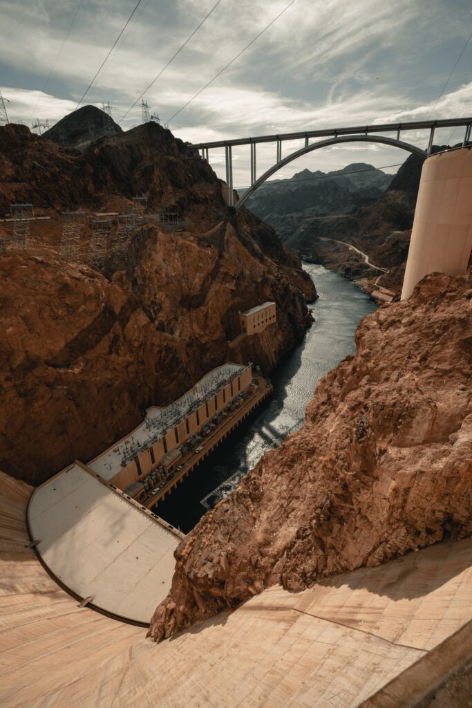
Dams interrupt the continuous flow of rivers but at times of flooding they may have to release more water through the spillways to ease the pressure on the dam wall structure.
That structure halts anadromous fish like salmon trying to swim upstream to spawn. Wealthy counties can build fish ladders like a series of locks or rapids.
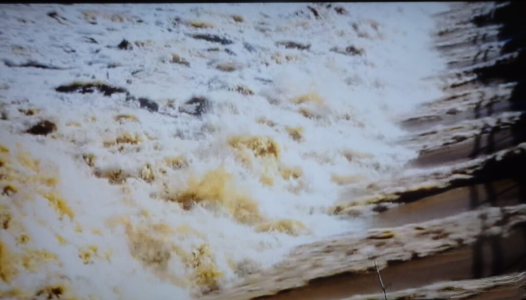
DAMS IN FLOOD
Dams interrupt the continuous flow of rivers but at times of flooding they may have to release more water through the spillways to ease the pressure on the dam wall structure.
That structure halts anadromous fish like salmon trying to swim upstream to spawn. Wealthy counties can build fish ladders like a series of locks or rapids.
VENERAL POOLS
The seasonal pool depends on underlying impermeable soils, often derived from volcanic flows. Spring is usually when these bodies of water are full. They provide a growth season for plants and animals. Peculiar plants have air containing stems that are buoyant, others have leaves that have adapted to float. As the water evaporates plants set seed which form concentric rings of flower shows. During the dry months amphibians dig deep into the mud to time their dormant phase.
Migrating birds will look to the vernal pools for nourishment and resting places alone their routes. These types of wetlands are threatened by drainage for agriculture or urban development, bush clearing for fire prevention, off-road vehicle use and most human activities. Legal protection for endangered species may give some leverage for protecting these aquatic eco-systems.
FRESHWATER STUDIES
Chemical
Acidity / Alkalinity; ph level
Nutrients and their source; where they are derived.
Physical
Turbidity; haziness / cloudiness
Erosion; evidence, causes
Depth of stream and flow rate
Biology
Netting to catch concentration of plankton
Quadrant sample count

Transect lines count and record occurrences of animal behavior. Leaf Litter; undersides and spaces between leaves, reveal insects and micro-organisms. Further information at Leaf Pack Network
STREAM STUDY: Water quality: clarity, temperature, and pH
Plants: numbers and varieties of plants in and adjacent to water.
Animals; numbers and species in and adjacent to water.
Human evidence: pollutants, litter or change of flow, drainage.
Seasonal change: Multiple surveys at various times. Further information at UGSU or EPA
Endangered Species in Peril: Further information at UsFWS and AuEnv and WWF and HSI and EES and NCA and AuGeo .
Water Cycle
The process and forms water takes on its journey around the Earth, from our oceans where heat from the sun evaporates the water as vapor into the air. At the molecular scale the water molecule that leaves the surface of the liquid draws another molecule to the surface where it heats and is also evaporated.
The minerals or salts the water molecules were carrying are left behind, increasing concentrations in the water body. The air above becomes progressively more humid.
The airborne water vapor travels upward and perhaps inland carried by air currents. Going higher the vapor molecules becomes colder, condense, cluster around suspended particles and form into clouds. Water vapor is clear so invisible in normal conditions, water droplets in clouds can be seen. When the mass of water is great enough precipitation occurs, as rain, or snow, or ice depending on the surrounding air temperature. The water descends and gravity acts to make it flow through the topographical landscape. Individual droplets combine to form creeks then rivers toward the lowest topographical locale.
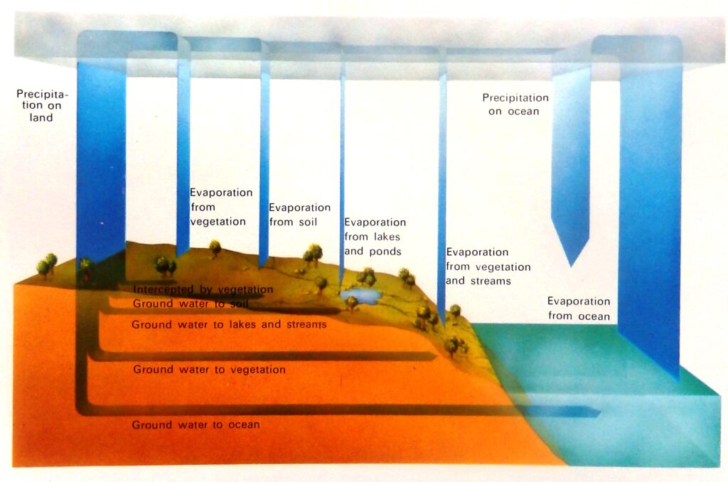
Water taken from the cycle
Percolation occurs when water passes into another layer of medium like soil layers or caverns. As water infiltrates through soil and rock, pollution is filtered out. Consequently aquifers are valued water sources. [ I cannot understand why counties permit the intermingling of subterranean layers by fracking to dislodge natural gas.]
Sublimation tends to occur in snow covered mountains in spring when temperatures warm the ice and snow into water vapor.
Water that has infiltrated the root system of plants is taken up to assist photosynthesis and cellular respiration, then release water vapor from the underside of their leaves by a process of transpiration. Water is also taken up by animals for cellular respiration and released from the body through urination, exhalation and sweat.
Transfer of minerals
Freshwater descending through the water shed erodes and carries downstream materials from the edges and bottom of the stream. Those natural materials can be particles of soil, decaying plant or animal parts or unnatural chemicals or waste. Storms increase the accumulation of pollution into waterways.
The Special Properties of Water
Collectively they make water unique. One oxygen and two hydrogen atoms satisfy each other’s electronic potential to bond in the Y configuration. Some say it looks like a head with ears, but the diagram below shows the balance ionic charge (polarity) and the angles of attraction allow the molecule to behave like a magnet. The oxygen end (negative) attracts positively charged atom or molecules, and the Hydrogen end (positive) attracts negatively charged atoms and molecules. This bipolar attraction allows water to be an effective solvent.
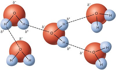
Water will dissolve salts like NaCl, and glues like gelatin. The negative (oxygen) side of water molecule will lightly bond with the positive (hydrogen) side of other water molecule. These are called hydrogen bonds which cause water molecules to stick together and in the liquid state give water its surface tension.
This attraction referred to as cohesion allows water to flow through plant tissue and blood vessels by capillary action. At the surface of a vessel or drop water will appear to be curved or dome shaped.
Water can exist in three states at relatively normal conditions. A liquid at room temperature because of the hydrogen bonds previously mentioned. They continually break and form with other water molecules as the water moves.
Ice is formed, when water is cooled below 0o Celsius with average air pressure at sea level. Water as a gaseous vapor can turn directly into a solid. Frost forms from the water vapor in the air. Water molecules arrange with hexagonal crystals in solid ice, which takes up more space than very cold water where the molecules are tightly packed. Ice partially floats because it is slightly less dense than the cold water surrounding it. Consequently water expands on freezing and tends to freeze from the top down.

Water vapor is the gaseous form also known as aqueous vapor. It is lighter (less dense) than air, so it rests above the atmosphere with the other ‘greenhouse’ gases like methane and carbon dioxide, and provides an insulating effect on the atmosphere. Tropical areas with high humidity will experience warm nights as aqueous vapor prevents the heat of the day to escape. In cold air aqueous vapor is quickly condensed into fog or mist or can form dew or frost on the ground. If all the Earth’s water vapor were condensed the surface of the planet would be covered by one inch of water.
Movement of Water
Condensation is the change from gaseous vapor to liquid droplets. Rain drops or snowflakes can be airborne we see in clouds.
Pressure can also activate condensation. Contact with cold surfaces an initiate condensation to liquid.
Precipitation in the atmosphere occurs when it is saturated with water vapor which then condenses and into drops heavy enough to gravitate to Earth’s surface. Saturation can be from the addition of more vapor or cooling in the air.
Fresh water annually on Earth’s surface amounts to 500,000 cubic kilometers (km3), unfortunately 395,000 km3 falls onto our oceans. Note that rain evaporated from the already existing water sources.
Although the rain may have been pure initially but if its fall path goes through other substances in the atmosphere like, ammonium, nitrogen and sulphur it may form ‘acidic rain’.
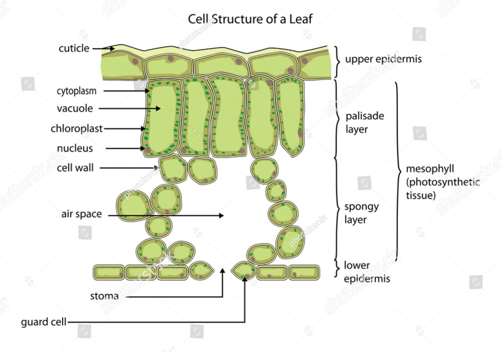
Evaporation is the transformation of liquid water to aqueous vapor. The transfer requires an amount of energy (heat) which is used, called evaporative cooling. When water evaporates from open bodies of water like a dam, the depletion rate, measured annually can be as high as 120 inches depth. Evaporation leaves behind substances which have entered the water sources like polluting chemicals, and may render them in toxic concentrations in those open reservoirs. Transpiration is how plants release water vapor from their leaves mainly and also stems, flowers and roots. A mature large tree may lose hundreds of gallons of water in a day which is up to 90 percent of the water absorbed through its roots. The under surface of leaves which are dotted with pores called stoma, which give off water vapor are bounded by guard cells that open and close the openings.[14]
Botanists have measured how much water a plant requires to grow, as an example cropping plants transpire from 200 to 1,000 litres of water (up to 1,000 kilograms) for every kilogram of dry material they produce, useful knowledge in arid regions.
Useful for us to know is that fresh water cannot just appear from the skies. The same water that occupied the surface and atmosphere of our planet millions of years ago is the water we see covering Earth today.
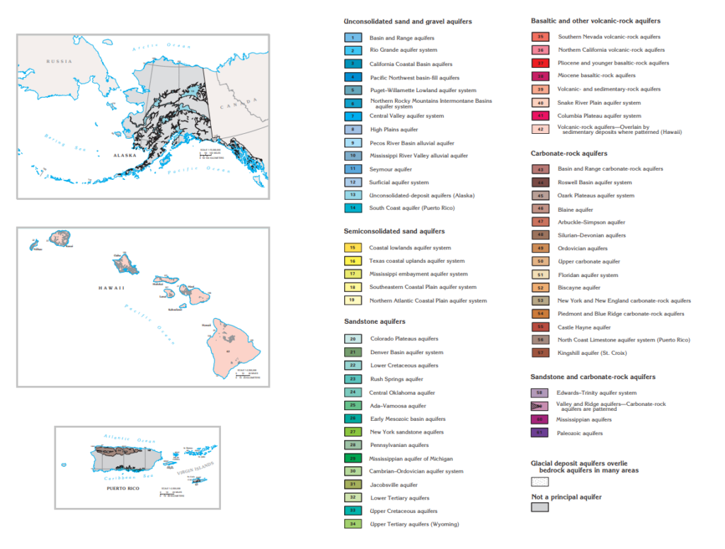
Underground Water Resources
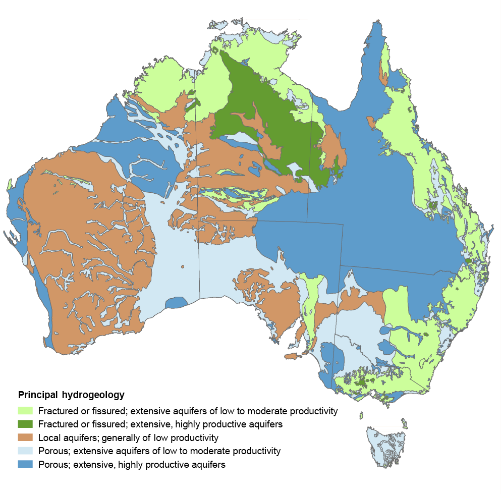
This map of the United States shows the different types and locations of aquifers which provide half of U.S. drinking water and also water to agriculture, industry and the environment. Over 75 years drilling and pumping has dramatically reduced the quantity held within underground aquifers.
Libyas Aquifers
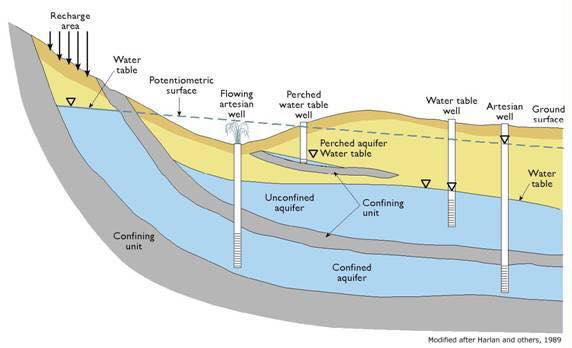
An aquifer is an underground geologic unit that is saturated with water that has sufficient permeability to yield that water to wells. A misconception exists that an aquifer is simply a large underground lake sandwiched between rock at both its top and bottom. This only exists in limestone caverns. The diagram below represents two different types of geologic materials, with different aquifer properties. As you can imagine, the well-sorted material allows water to move quickly through it (larger pore space), while the poorly sorted material requires a bit more energy and time for water to travel through it (see diagram below).[15]
This study is to examine the physico-chemical quality of the Libyan Murzuq groundwater, to find the extent of its pollution and compare the quality standards for drinking water. Samples from 13 boreholes and the water wells of Sabha, in the Libyian localities. The criteria studied were temperature, conductivity, salinity, acidity – alkalinity and hardness. The total dissolved solids (TDS) including presence of; Aluminum, Fluorine, Potassium, Sodium, Calcium, Magnesium, Iron, Copper, Manganese, Chloride, Sulfate, Silica, Nitrates, Nitrites, Ammonium, Ammonia, Nitrogen, Bicarbonate, Phosphate, Calcium Carbonate. Analysis showed that the groundwater of Murzuq was within the limits of Libyan Standards. However, some elements’ analysis showed high conductivity and concentrations of; TDS, Potassium, Sodium, Iron, Copper, Chloride, and Manganese. Questions persist to decide whether to limit the use of those waters for drinking.
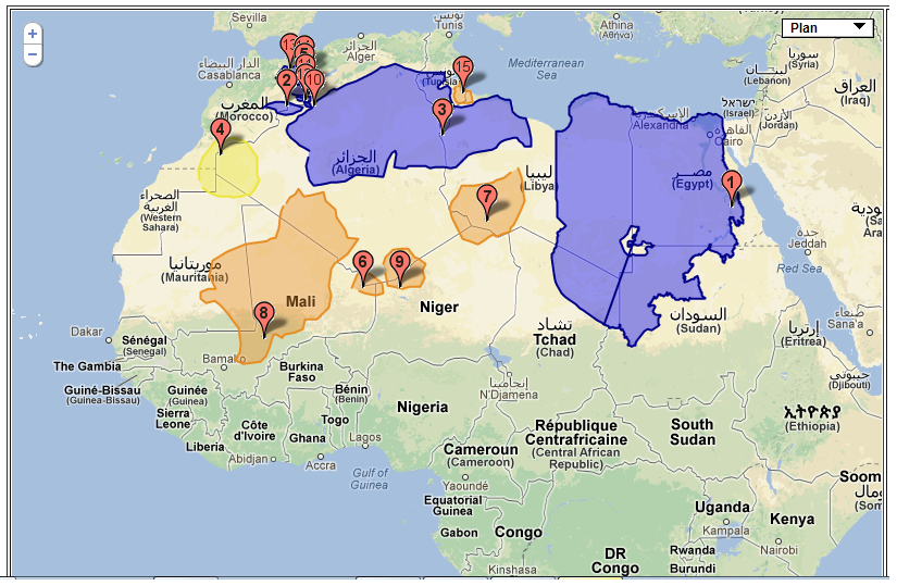
More on the Murzuq basin and Water resourses in the Arab Regions see Further Reading below.
Groundwater and Water Management
Dr. Ralf Klingbeil of the Federal Institute for Geosciences and Natural Resources (BGR) Hannover, Germany, published (Nov 2012) a set of slides on the topic;
Groundwater and Water Management Issues in the Middle East for the Economic and Social Commission for Western Asia (ESCWA).
Download the PDF to appreciate the diversity and extent of the problems involved in maintaining a supply of drinkable water for all.
Replenish Groundwater
Dr Stuart Khan says more innovation is needed to achieve improved water security[16]
Natural cycle: How large quantities of waste water can be replenished naturally. Groundwater is currently being replenished in Western Australia and Queensland.
Australian Groundwater Resources LINK
Salt Water
Fresh water only accounts for 2.5 percent of the Earth’s total water, which leaves 97.5 percent of our water occupying 71 percent of the Earth’s surface. Even now some underground water reserves are highly brackish. Most of New Mexico’s underground water requires treatment for its saline concentrations.[17]
Desalination of water
Two common methods of removing salt and impurities from water are forced distillation and reverse osmosis.
Forced distillation is the heating of the water until it evaporates then collected and condensed to liquid. The contaminant elements need to be physically separated from the water vapor by a filtration or trapping.
Reverse osmosis pumps water through a membrane that selectively filters away the salt ions. A cheaper method than paying for the energy required to heat water to boiling point.
Forward osmosis is more effective than reverse osmosis, it uses the movement of water molecules through a membrane into a ‘draw solution’. The draw solution is more concentrated in a special salt which is then evaporated using a low-grade heat.
Carbon nanotubes positioned in an impervious membrane restricts water flow through the tubes where an electric charge is applied that repels the positively charged salt molecules in sea water. The neutrally charged water molecules can pass through the tubes without the salt. This process requires relatively low pressure pumping. (I don’t know what happens to the negatively charged chloride ions, hopefully they are attracted to the electric charge and hold to the tube charged surface?) Biomimetics as the name suggests mimics the live cell membrane called aquaporin, a protein that conducts water in and out of other cells. The aquaporin like nano devise applies a positive charge at the protein’s aperture which repels the salt molecules.
More on water and water management like the synthetic mangrove in Further Reading below.
References
[17] Alley, William M., Desalination of Groundwater, 2003. http://pubs.usgs.gov/fs075-03/
[16] Dr Stuart Khan says more innovation is needed to achieve improved water security, Matthew Kelly, Newcastle Herald News, 2 Aug 2019. LINK
[15] :http://www.GeologyofLibya.com/
[14] Water Cycle and Water Reservoirs, by Anica and Abraham Miller-Rushing, Marcia Matz, Enviromental Literacy Guide, National Geographic
[13] This Is The Largest Earth Science Experiment. What Went Wrong? Youtube.com
[12] Revenga and Mock, study 2000.
[10] Needing Water, Georgia Stirs Up a 200-Year-Old Dispute With Its Northern Neighbor. Austyn Gaffney NRDC Oct. 29 2019
[11] Disappearing Lake Powell underlines drought crisis facing Colorado River. Chris McGreal, The Guardian 18 May 2015
[9] WWF worldwildlife.org, freshwater systems
[8] Science and Technology.Brown.Edu/news/2021-03-03/water
[5] Humans Now Control The Majority of All Surface Freshwater Fluctuations on Earth, Peter Dockrill, 7 March 2021, Science Alert.com
[6] National Geographic Resource library Educator Guide Earth’s Freshwater
[7] Menindee’s massive Lake Pamamaroo fills just in time for town struggling after drought, fish kills, Declan Gooch, 15 June 2020, ABC.net.au.
[4] The Racing Stripe Darkling beetle Wikipedae Stenocara gracilipes
[3] Huang, W. et al. Mechanism of water extraction from gypsum rock by desert colonizing microorganisms. Proc. Natl Acad. Sci. USA 117, 10681–10687 (2020)
[1] Groundwater and Climate Change, WRL Technical Report 2017/04 May 2017 by D J Anderson
[2] “Robert Fulford’s column about Petra, Jordan”. Robertfulford.com.1997-06-18. Archived from the original on 2015-09-24
Further Reading
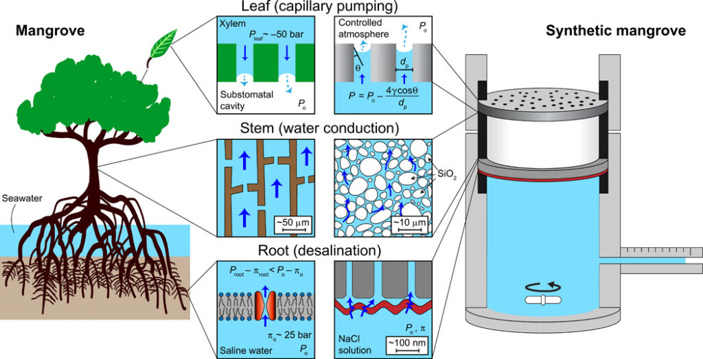
Capillary-driven desalination in a synthetic mangrove, Yunkun Wang, Jongho Lee, Jay R. Werber, Menachem Elimelech, Science Advances 21 Feb 2020: Vol. 6, no. 8, eaax5253 DOI: 10.1126/sciadv.aax5253 LINK
The schematic diagrams show the mangrove tree (left), the synthetic mangrove device (right), and their water transport mechanisms (center insets). In natural mangroves, capillary pressure created by evaporation into substomatal cavities (top left inset) brings about upward water transport through xylem channels (middle left inset) and desalination by aquaporin water channels in root cell membranes, which exclude salt from saline water in the soil (bottom left inset). The highly negative pressure in the root, Proot, overcomes the osmotic pressure of the saline water (πo), which enables water uptake through the root filtration system (i.e., Proot − πroot < Po − πo). The synthetic mangrove as shown comprises a nanoporous AAO membrane, a silica frit, and an RO membrane, mimicking the leaf, stem, and root of natural mangrove trees, respectively. Negative capillary pressure in the nanopores of the AAO membrane (top right inset) is the driving force for water transport through the silica frit (middle right inset) and desalination of saline water by a semipermeable RO membrane (bottom right inset). Hydrogel membranes are also used as leaves. Membranes were sealed using rubber O-rings, shown in black. Magnetic stirring is used to enhance mixing of the saline feed water and minimize concentration polarization at the membrane surface. Pleaf and Proot, xylem sap pressure at the leaf and root, respectively; Po, pressure in the soil or feed water; πroot, osmotic pressure of xylem sap at the root; πo, osmotic pressure of soil or feed water (~25 bar for seawater); γ, water surface tension; θ, water contact angle on nanopore wall; dp, nanopore diameter.
Water purification
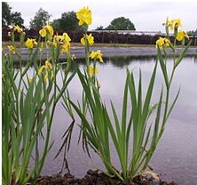
The yellow iris (I. pseudacorus) is often used in water purification. The roots are usually planted in a substrate (e.g. lava-stone) in a reedbed-setup. The roots then improve water quality by consuming nutrient pollutants, such as from agricultural runoff. This highly aggressive grower is now considered a noxious weed and banned in some states of the US where it is found clogging natural waterways.
Biomimicry Desalination. True to its global hydrohub reputation, Singapore is hoping to reduce current energy requirements for membrane desalination from 3.5kWh down to a miraculous 0.8kWh/m3. May 1st, 2012, Harry Seah is the chief technology officer of PUB in Singapore. LINK
Demi Sec: Spanish Lessons for Australia in managing Dry-Climate Historic Parks and Gardens
Link: The Pratt Foundation and ISS Institute Overseas Fellowship
Water in volcanic locations: New Zealand lava fields
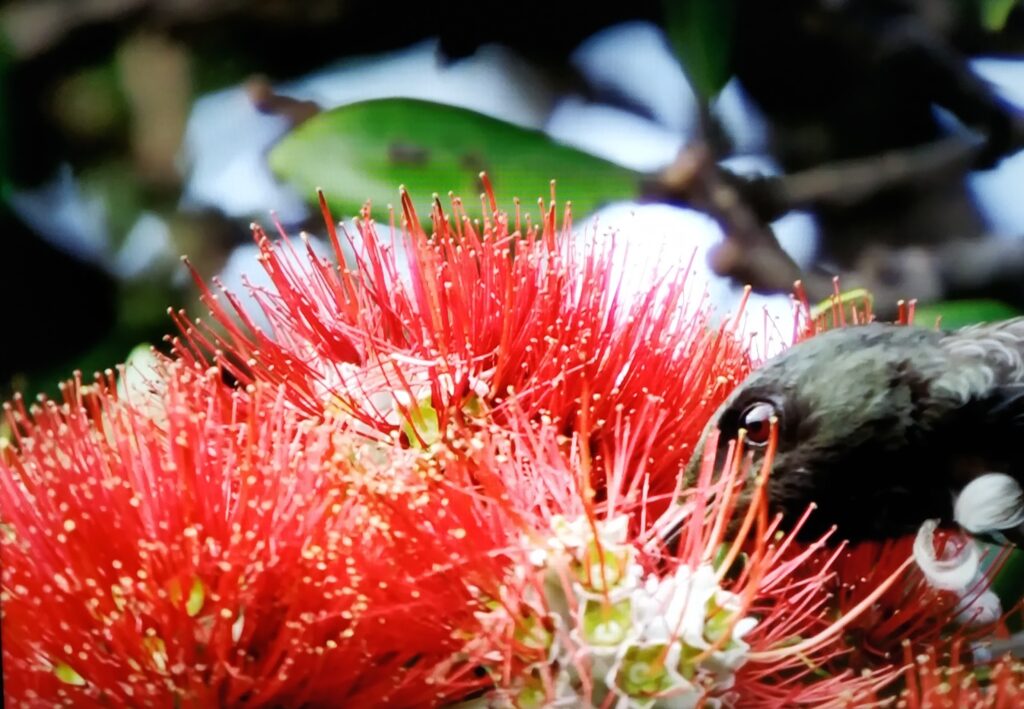
Moari named pohutukawa is a coastal evergreen tree of the myrtle family that produces a display of red flowers of massed stamens. Its ability to survive even perched on rocky, precarious cliffs has positioned it in New Zealand culture as a chiefly tree. The tree makes nectar available to native birds and unfortunately very attractive to the introduced brushtail possum.
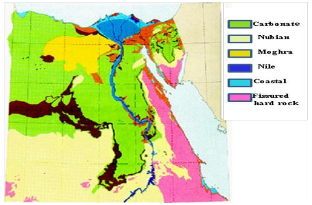
Groundwater of Egypt
Groundwater of Egypt: “an environmental overview” pub 12 Sept 2007
M. R. El Tahlawi, A. A. Farrag & S. S. Ahmed
Although Egypt has the great Nile River, which is the main supply of water, Egypt’s water is limited to 55.5 billion m3 per annum. Owing to the rapid growth of the population and the increasing consumption of water in agriculture, industry, domestic use, etc., it is expected that Egypt will rely to some extent on groundwater to develop the new projects such as Tushka in Upper Egypt and East Oweinat. Issues related to groundwater in Egypt are identified with the common geological features associated with formation of the aquifers and demonstrating the location of the main resources of groundwater, followed by the main objective of this paper, which is addressing the environmental issues related to groundwater in Egypt. Several studies have been reviewed and personal communication made with the authorities to introduce this work and provide an overview of the groundwater quality problems in Egypt with examples from different parts of the country.
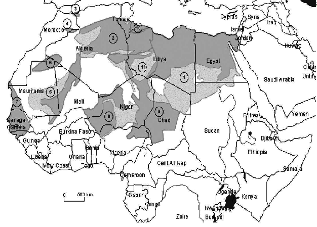
Murzuq basin is located on the southwestern of Libya (Figure above) between Jabal Fezzan (28°N), Jabal Qussa (16°E), Chad-Niger (South) and Algeria (West). The wells penetrated from top to bottom, Quaternary deposits, the Nubian sandstone (Lower Cretaceous age) and upper part of the post Tassilian deposits, Jurassic (Touratine Formation) and Triassic (Zarzaitine Formation).
High Naturally Occurring Radioactivity from Fossil Groundwater in the Middle East
High levels of naturally occurring and carcinogenic radium isotopes have been measured in low-saline and oxic groundwater from the Rum Group of the Disi sandstone aquifer in Jordan. The combined 228Ra and 226Ra activities are up to 2000% higher than international drinking water standards. Analyses of the host sandstone aquifer rocks show 228Ra and 226Ra activities and ratios that are consistent with previous reports of sandstone rocks from different parts of the world.
- Reference Project: Radioactivity in the Deep Aquifer System in Jordan Avner Vengosh, Daniella Hirshfeld, David Vinson, Gary Dwyer and others DOI:10.1021/es802969r
Recognizing the vast uses of water in human life, the presence of α and β particles emitting radionuclides in groundwater of northern Saudi Arabia has been evaluated as a means of water quality assessment of the region. A liquid scintillation counting technique was used to determine the gross α/β, and 228Ra radioactivities in water samples, while the radioactivity concentrations of 234,238U and 226Ra were determined using alpha spectrometry after the separation process. Present results show that all water samples contain a higher level of gross α and β radioactivity than the WHO recommended limits; the average gross α activity is about 7 times greater than the limit value of 0.5 Bq L-1, while the average gross β activity value is about 3.5 times greater than the limit value of 1 Bq L-1. Correlations of TDS and pH with gross α and β radioactivity in the studied samples were investigated
Ref; Assessment of radioactivity contents in bedrock groundwater samples from the northern region of Saudi Arabia DOI: 10.1016/j.chemosphere.2019.125181
Fahad I Almasoud , Zaid Q Ababneh , Yousef J Alanazi, Mayeen Uddin Khandaker , M I Sayyed
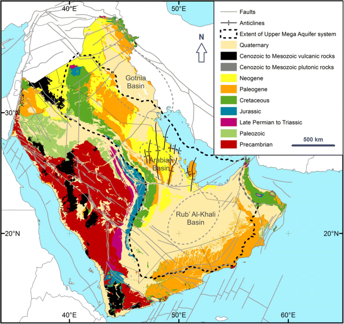
Groundwater availability and water demand sustainability over the upper mega aquifers of Arabian Peninsula and west region of Iraq. pub 8 Jan 2020. Salih Muhammad Awadh, Heba Al-Mimar & Zaher Mundher Yaseen
The current research is devoted to highlight the past, present and future status of groundwater characteristics over the Arabian Peninsula (AP) and west region of Iraq. The Umm er Radhuma, Rus Dammam and Neogene deposits are the major hydrostratigraphic units supplying the main groundwater resources in the AP. Water shortage is still a major problem for many countries in the world, including oil-producing countries such as Iraq, Saudi Arabia (SA), the United Arab Emirates (UAE), Qatar, Oman and Bahrain. The withdrawal of groundwater has been reflected in salinization of agricultural soils, leading to an increase in high-cost technologies such as desalination of seawater to provide suitable water for diverse sectors. Hence, the use of seawater desalination as a major source of water is unavoidable, and country development requires the use of renewable energy as protection of the environment. The need to conserve and use groundwater resources efficiently is highly essential owing to the fact that it is the only natural source of water in such developing countries of global importance. The review comprises various essential components related to groundwater variability including the hydrogeological aspects, climate change, drawdown and abstraction, rainwater harvesting, desertification and population increment.
Transboundary Water and Transboundary Aquifers in the Middle East: Opportunities for Sharing a Precious Resource Published 2010
R. Klingbeil, M. Alhamdi
Surface and groundwater resources in the Middle East are to a large extent transboundary. While much attention is given to the surface water and river courses crossing national boundaries in the region little has been achieved in understanding the sometimes hydrogeological complex transboundary aquifer systems. Much political attention is given to the rivers Euphrates, Tigris, Jordan and Nile as they connect Arab and non Arab countries. However, also between the Arab countries surface and groundwater crosses political boundaries and only few regional organizations address the need for improved internal Arab cooperation on shared water resources. An overview of confirmed and potential transboundary shared surface water and aquifers between ESCWA member countries and between ESCWA member countries and non member countries will be presented. Often detailed hydrogeological knowledge is still limited at national or trans-national level on the individual transboundary shared aquifer, some bilateral or multilateral cooperation between riparians (water course and aquifer states) have been taken place and are taking place in the region. In most cases the principles underlying the UN 1997 Convention on the Law of the Non-navigational Uses of International Watercourses and the UN General Assembly 2008 Resolution on the Law of Transboundary Aquifers as well as basic principles of IWRM applied in a transboundary context are already considered to some extend as guidance for individual cooperation mechanisms that may eventually develop into bilateral, multilateral or regional agreements and/or conventions. ESCWA supports its member countries towards bilateral as well as regional cooperation mechanisms through a number of tools such as the cooperation through the Committee of Water Resources and activities of the ESCWA work plan, shared water resources assessments and guidance, development of negotiation skills, dispute resolution and regional advisory services responding to specific requests from member countries.
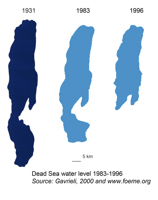
Raising the Dead Sea
Dead Sea Level evolution since 1800.
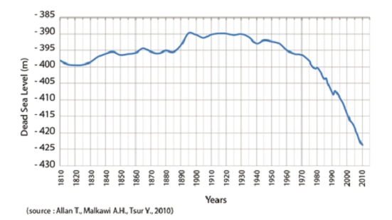
The project to channel water from the Red Sea to the Dead Sea has fascinated people for the past one hundred and fifty years. It was brought back to the fore in 2005 by the three neighboring countries: Jordan, Israel and the Palestinian Authority. The stated goals are to halt the decline of the Dead Sea (fig. above) and to save it from environmental damage (fig. below), to desalinate water and produce affordable energy for all three countries, creating a symbol of peace through a tripartite cooperation (World Bank, 2005). However, the project, at a cost of over $11 billion over twenty years, requires regional stability that is far from being achieved.